


ejstubbs
-
Posts
2,163 -
Joined
-
Last visited
Content Type
Profiles
Forums
Blogs
Gallery
Events
Exhibition Layout Details
Store
Posts posted by ejstubbs
-
-
When I was a kid living in Derby in the 1970s, I used to enjoy going to the Museum and Art Gallery on the Strand on Saturday mornings to see their 7mm Midland Railway model running. I was musing about it the other day and had a look online to see whether the model was still in existence. It appears that it moved out of the Strand premises to the Silk Mill some time in 1980 but I can't find any reference to it after that date - apart from this article in the Derby Telegraph mourning its demise, and suggesting that it last ran in April 2011 (or maybe 1980, the article isn't 100% clear).
Does anyone know what happened to it - at least to the locomotives and rolling stock, if not the layout itself?
Update: this entry on the Gauge O Guild web site suggests that the model was effectively mothballed around 1981 and is now dismantled. (It seems that you have to join the guild in order to view the slide show.)
-
PS Aldgate is bigger than Liverpool St? Are you sure?
It's the Metropolitan's sub-surface Liverpool Street station* that inspired Minories, not the GER one. As I say, look at the track plans posted by Clive Mortimore and it should become clearer.
(Personally, I miss Broad Street station. It was a much more pleasant journey in to the City from Hampstead Heath station than hiking up to Haverstock Hill and being shoggled about, sardined in a sweaty mass of commuters, from Belsize Park to Moorgate.)
* Called Bishopsgate up to 1909 - see here. Not to be confused, again, with the GER's Bishopsgate station, which the surface level Liverpool Street station replaced in 1874.
-
 1
1
-
-
Minories (the road) links Fenchurch Street and Aldgate. It's too much of a coincidence that these two urban stations can't of been some influence to CF and his design.
I think it more likely that CJF was simply looking for a name for his design from a location in the City, much like the Finsbury Square layout mentioned on another Minories thread. Minories is an interesting sort of name that wouldn't necessarily be recognised as a street name by a fair proportion of people, I suspect. Minories the street isn't that far from Liverpool Street (let's face it, nowhere is that far from anywhere within The Square Mile - 1.4 miles maximum if Pythagoras is to be believed!) and is also the name of a former civil parish covering that area of the City. (Plus, although it does trip a fair few people up, it's easier to get the pronunciation right than St Mary Axe!)
If you look at the diagrams linked by Clive Mortimore, it's pretty obvious that Minories really is Liverpool Street re-imagined as a terminus, with the single slip replaced by two points. In other words, pretty much exactly what you'd expect from CJF's description of how he came up with it, as he recounted in the September 1981 issue of Model Railways (see this posting for an edited transcript). Aldgate is quite a bit bigger than Liverpool Street, although it does seem to have a loco spur which might be one feature which CJF borrowed for Minories. Fenchurch Street has a relatively long throat - almost 50% longer than the station platforms due to having a ladder of crossovers on the approach, whereas Minories can fairly easily be built with the platforms longer than the throat. Fenchurch Street is again noticeably larger than Minories which, combined with the more relaxed space constraints, IMO doesn't make it an obvious inspiration for a design which was deliberately intended to be compact.
All that said, I'm sure that CJF had lots of ideas gleaned from different prototype locations that he'd visited filed away in his head, so there could be any number of locations that could lay claim to inspiring certain details of the Minories design.
-
1
-
-
It may well be a signalman who worked the box is still around who can tell you how it was operated in reality, not necessarily as the rule book suggests
That's a really interesting suggestion. Any ideas how might one go about tracking down such an individual?
-
This is all making sense, thanks again to everyone for sharing the benefit of your knowledge and experience.
And apologies for the problems with the signal box diagrams; they seem only to be accessible via the page that Dave Scott linked, direct links to the gifs' URLs get blocked.
-
Many thanks to everyone who's responded to my question, especially for the insight in to how goods trains were shunted. Obviously train length (and available space) will be a consideration as the design comes together.
I will try to make sure that, on completion of the layout, my shunting is carried out in such a way as to maximise the opportunities for refreshment intake!
Probably only shunted by trains heading in one direction and I would think most likely shunted the easiest way - probably by by a Down train working as you surmise.
And, fairly obviously, traffic for that station would be formed rear on arrival to simplify, and speed up, the shunting with teh rest of the train left in the Down loop.
But it would be worthwhile trying to find a signalling diagram as that would reveal if the layout was signalled for an Up train to do what you suggest.
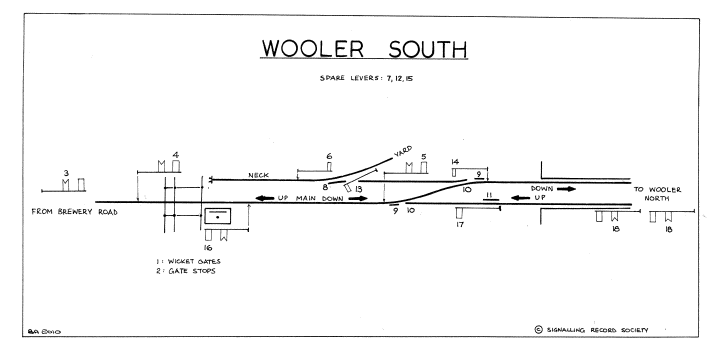
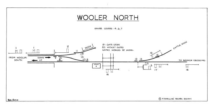
I was pleasantly surprised to be able to find the relevant signal box diagrams online: Wooler South and Wooler North. Unfortunately I'm not very good at reading such diagrams, but I think there's no way for the Wooler North box to signal an up train on to the down platform. OTOH, does that mean that I couldn't operate my layout that way, if I signalled it differently? I'm not aiming to model Wooler slavishly, if I could get a bit more operating interest out of it.
The signal box diagrams do include a couple of new gems of information. Firstly, the spur at the north end of the down loop appears to have run to a goods dock of some kind that isn't clearly indicated on the OS map. On closer inspection I can see that it probably is shown, although an earlier edition shows what appears to be a wagon turntable on the spur. Intriguing...
Secondly, the road crossings appear to be level crossings rather than bridges, which creates a little more railway interest. The railway and the road both cross the Wooler Water, though, so the scenery still doesn't have to be boring and flat. Which is nice.Thinking about that level crossing at the south end gives me another idea: an up train could have stopped past the station, just short of the crossing, and propelled back in to the down loop to then access the headshunt. Would that sort of thing have been done at all commonly - or even at all? -
I'm in the process of creating a layout design which is very roughly based on Wooler station on the NER Alnwick to Cornhill branch (that line was also home to Kilham Sidings, supposedly the prototype inspiration for Wright Lines and Inglenook Sidings). I'm only working from the station layout between the two road bridges (over the modern-day B6525 and B6348). I'm ignoring the auction mart to the north and its sidings, at least for the moment.
The station is on a single track main line, with a loop for the station platforms. The goods sidings at the station are accessed via a headshunt off the south end of the down (northbound) side of the station platform loop. I'd like to understand how this arrangement would have been operated, assuming that both up and down goods services used this yard. My guess up to now is as follows:
- down goods services would arrive at the down platform, the engine would run round using the loop and depart the down platform 'wrong way' in to the headshunt;
- up goods services would run 'wrong way' through the down platform and straight in to the headshunt.
Does that sound right, or would it have been operated some other way?
Bear in mind that there will be fewer sidings in my layout - in particular the siding incorporating a loop (which I think runs to a row of coal drops/bunkers?) will not be included.
(I'm also wondering about the function of the spur at the north end of the down platform. Would this have had a particular function that I could usefully incorporate in my layout?)

Derby Museum Midland Railway model
in Modelling musings & miscellany
Posted
Thanks everyone for your input. Good to hear from other folks with memories of the model in its original location.
John, great to read of your involvement with the model in the past.
Mike B, relieved to hear that it looks like there is still a model at the Silk Mill. If Dovedale Models have been providing buildings then that would seem to chime with John's comment about the volunteers' scenic work being replaced by professionally-produced models. If you could ask around for more information, I would very much appreciate that. It would be a great shame if too much of the original model had been lost, especially the rolling stock.
If it's simply been hibernating and is going to re-emerge bigger and better then I might even have to find an excuse to pop down to Derby again one day to visit it, and see if I can re-create some of that Saturday morning excitement! I might even try to get a tour of the Roundhouse. In fact, looking at your signature, it looks like your club's exhibition there in May next year might provide just the motivation I need to make the trip.
The old place does seem to have changed a lot since I was there as a lad. Hard to believe that the Baseball Ground with its skew-wiff stand has gone completely. At least when Highbury was redeveloped they retained the listed stands; it's disappointing that no part of the Baseball Ground was ever listed.