


Crun
-
Posts
937 -
Joined
-
Last visited
Content Type
Profiles
Forums
Blogs
Gallery
Events
Exhibition Layout Details
Store
Posts posted by Crun
-
-
2 hours ago, Donington Road said:
For those who might be interested there is an article on the Werrington Upgrade in the latest edition of Rail Engineer.
It can be viewed and/or downloaded here:
Very detailed technical article. Some of it over my head. Must have another read later on this week.
-
13 minutes ago, Donington Road said:
Thanks Crun, I'm not a birdie (or should I say Ornithologist) so please accept my ignorance.
They all look the same to me from a distance.

Or a birder even...
")
")
-
 1
1
-
-
44 minutes ago, Donington Road said:
Part 4
Wild life trip continues.
In the field opposite Sobrite Spring is the new wildlife area created by Network Rail to house the displaced Greater Crested Newts and other amphibians.

It being such a nice day I thought I would carry on to Hurn Road to video a few trains.
Looking at the videos later a home I spotted these two, a Buzzard surveying an approaching Azuma, and our resident fox having a wander in the wide way.


End
It's a female Kestrel.
")
")
-
 1
1
-
 1
1
-
-
On 28/01/2020 at 19:30, Richard E said:
Just seen some photos on Twitter from someone called Rick Barsby. These are interesting as he is obviously on site. I've got permission to use his pictures.
This first one is, from the angle of the sun and the cutting, obviously the eastern portal of the dive under.

This next one is the same place looking the other way with the guide tunnels quite obvious.

And finally the eastern portal from ground level. I've posted something similar some pages back but the base has now been cast.

Another view looking down into the portal area.

And a final view across the portal area.

Very interesting 'insider' photographs. Any more that arrive on Twitter always welcome in this thread. Many thanks!
-
1
-
-
2 hours ago, Richard E said:
Taken a look this morning. Not a lot to see really but a couple of update pictures anyway. I parked on Davids Lane and walked across to Hurn Road footbridge and back.
The new haul road is now becoming a tarmac roadway that looks fairly permanent. The walkway that was staked out has disappeared as well. I'm not sure if it is new but there is an LED signal on the down joint just past the Bailey Bridge that I didn't think was there before. Whilst I was there the last of the dumper trucks that was used to move the lime was being loaded on to a low loader to be taken away.
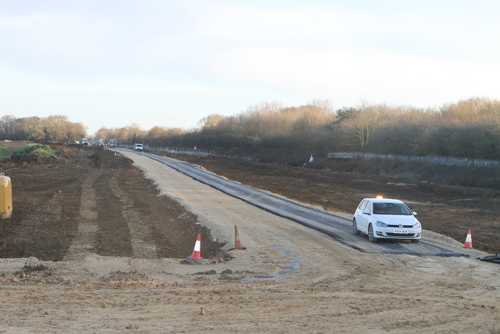
And they are piling under Werrington Parkway (A15). The machine here not only drills the hole for the pile (with an auger) but will also inject the concrete. The pipe for this can be seen leading to the concrete pump and cement mixer. There were about 30 preformed rebar units lying around here a week ago, now there are just 10.

And it is still very wet at Hurn Road.

Little else to see here so I went down to Cock Lane bridge, one other person taking pictures of passing trains here. It can be seen that they are working on the access to the dive under although the piling unit has moved to the east wall of the dive under itself. With resting the camera on the edge of the footbridge I keep getting a sloping horizon which I've corrected! Must remember my monopod for the future. More to carry what with the steps as well.

And, for today, that is your lot from me.
Many thanks for the excellent photographs.
Why were they putting down tarmac?
That plastic heron had me fooled when I rode past it just after Christmas!
-
1
-
-
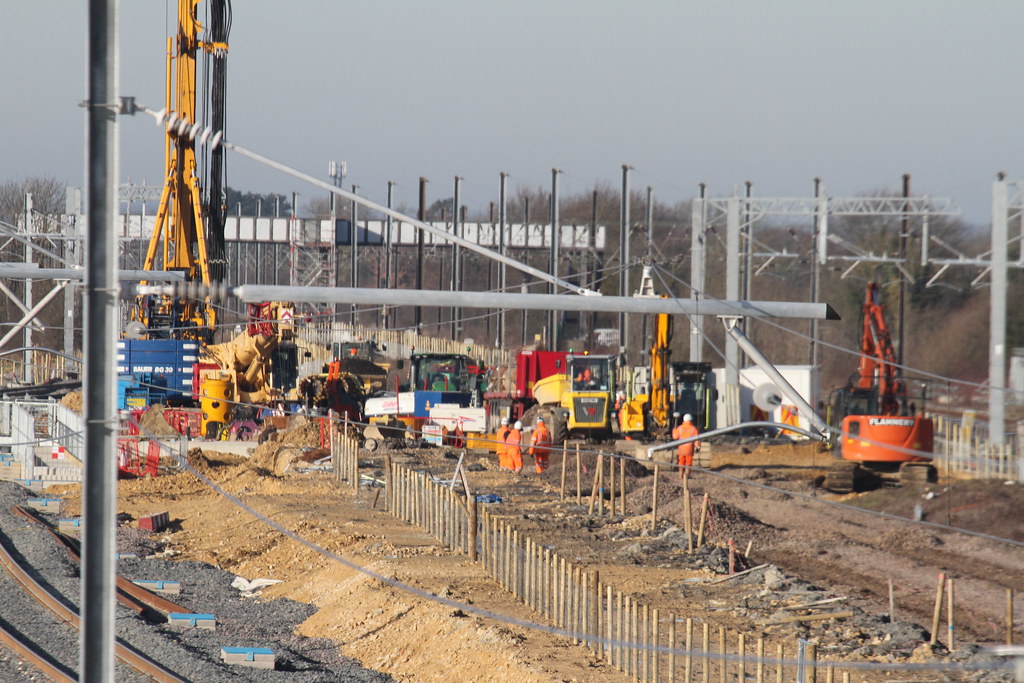
On 20/01/2020 at 16:12, Richard E said:
Been over late morning after popping in to see my daughter.
Starting with the Joint Line works it was cold last night and one of the dumper trucks being used to move the lime was in need of some help in starting! It didn't seem to be terribly effective though. When they turned the dumper on the left around to face nose to nose it was evident that these are 6x6 beasts.

Quite a bit of heavy kit here now and some work in evidence. there was a bulldozer being fuelled just out of shot to the left as well, hand cranked pump from a fairly large tank. Some of the kit is from local companies, not just big nationals. This side is pretty wet underfoot at the moment.

They've got pumps on Morgan Lake too.
There are still plenty of old track panels on site stacked along the old Stamford up line.

And they are very much working between live running lines.

The work on this side seem to be concentrated on digging out the access 'tunnel' under the new up and down Stamford lines. the second of these pictures shows that this side of the site is still pretty wet in places.

Finally back to the underbridge on the A15 and there is evidence of the raised walkway location. The raised area visible appears to be for services but to the right of that can be seen, at ground level, a further concrete plinth which I assume will be the line of the footpath. Some rebar is visible sticking up vertically about 6" further out, I assume that this is in place as alignment markers, I can't see any other reason for it being there.

They also seem to monitoring the bridge itself for movement, there are 6 of these detectors on the bridge piers, three each side of the bridge. One is also visible in the picture above.

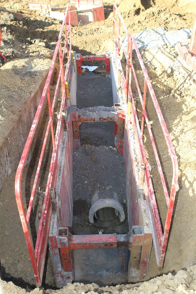
And finally, just by the path from Stirling Way to Cock Lane footbridge there are some final drainage pipes going in.
Hopefully all this is of interest, progress seems slow at the moment so I've not really bothered going out much recently.
Just managed to ride a loop around Werrington and Marholm to look at and ride over the newly opened Bailey bridge. I also took in the views from the Hurn Road bridge and the Cock Lane bridge. A bit wet to begin with but the sun came out mid-morning.
-
20 hours ago, Donington Road said:
Popped out this afternoon to see they have smuggled the pile driver into the centre.
All the track from the down Stamford that was stacked up around the site has been removed by road. (I hadn't noticed until it was pointed out to me by someone else, I mean, there was so much you couldn't fail to miss it
 )
)
The main site to the west looks to have had a bit of a tidy up since the track has gone (now why didn't I take a photo?
 )
)
All the Up Stamford track is still stacked up in the centre between the two live lines.

That's some impressive piece of machinery! Thanks for all the updates and photographs. I must get out on the bike next Sunday, weather and road conditions permitting.
-
1
-
-
On 17/01/2020 at 18:59, Donington Road said:
That is quite a substantial structure. The one here at Werrington is more lightweight although it does carry electric, water and telecoms utilities which will eventually go back once the adjoining road bridge to the left is built.
There is also a lot of wood and string in the build so maybe they were erring on the side of caution when they built the supports


I was going to visit this at the end of my usual cycle ride with Peterborough Cycling Club this morning but will delay my start as I've had a warning of icy conditions on the roads. Several people came off their bikes yesterday I have learnt. Must explore this bridge when safer. Thanks for the news Mick.
-
1
-
-
Information about line closures at Kings Cross affecting weekends in January and February:
https://www.lner.co.uk/travel-information/travelling-later/kings-cross-u
-
2
-
-
Any more up to date news and photographs welcome. Are there to be more line closures from Kings Cross northwards this month and beyond?
-
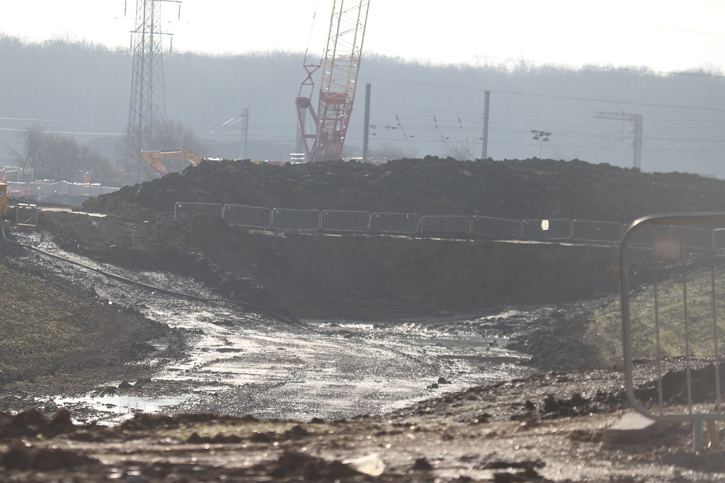
1 hour ago, Donington Road said:
Some heavy machinery has moved into a very boggy area east of Lincoln Road.
The view is looking towards the eventual junction with the Joint line just before Foxcovert Wood in background.
The temporary footbridge in the foreground which was due to open on Monday is still not open.
Unfortunately not being able to get it out of the frame it has blurred the background somewhat.


Tresspasser on the Up Slow at Hurn Road.
Where's your hi-vis?


Fox on the run! I saw one on the western side of the ECML heading south as the Fitzwilliam hunt headed north! This was around Christmas time 2018.
-
13 hours ago, Donington Road said:
I was going to put together a video of the whole weekend shutdown but as there were many short video clips to assemble it started to get a bit unweildy.
So I have decided to make the video in parts which also helps me with the rendering process and prevents my computer throwing a few wobblies.
I am sorry that some clips are a bit wobbly in places as I do all shooting hand held and old hands tend to wobble more than I like, plus the wind is a nuisance at times on those exposed bridges.
Talking of wobbles, note the container flats on the up Stamford, especially the three rear ones.Part 1 is Friday afternoon before the 22:30 possession showing the new and old Stamford lines in use before the Up Stamford line is joined to its new alignment.
I thought it gave some unusual views with the width between the Up and Down lines, although when the dive-under is completed the width will be even greater as the Up Stamford will be moved back closer to the ECML.Many thanks for the video. Good to meet you earlier this afternoon. I am now warming up after my cycle ride and a late lunch. I am glad I had my winter Peterborough Cycling Club jacket on plus extra layers!
I have posted a few photographs from my mobile phone.
-
2
-
-
23 hours ago, rockershovel said:
I can certainly tell you that rodding them is an absolutely horrible job!
We had dirty, rusty water flood people's lockers and we had to have the floor up to fix electrical problems.
-
Views from the Cock Lane bridge. The first two looking north and last one looking west 05/01/2020


-
 4
4
-
 1
1
-
-

View from Hurn Road bridge looking south 05/01/2020
-
2
-
-
5 hours ago, jamie92208 said:
As to the cast iron columns. They were often hollow and did a double duty as roof supports and also downpipes for rainwater. If they are no longer needed structurally they may well have collected water in them. I duscovered this when researching station canopies for my modelling.
Jamie.
Yes you are quite right, I should have said that they double as downpipes and roof supports. I think the people who cleared them claimed they had been blocked with building materials.
-
1
-
-
Many thanks. I must remember that when I am next in the building. This forum is one of the most friendly and informative ones I belong to. I must have a ride around the area and use the bridges at the end of my regular cycle ride on Sunday and see if there are any developments since last Sunday.
-
2
-
-
Thanks for the link. I work with all sorts of maps, aerial and satellite photographs as part of my job. I have looked at the map series you used amongst others. I have worked on maps of nature conservation designations such as SSSIs (Sites of Special Scientific Interest) and NNRs (National Nature Reserves).
-
1
-
-
6 minutes ago, melmerby said:
Can you point it out on a Google earth view?
Someone might be able to give more information on it's origins.
It's called Unex House, PE1 1NG. Another similar building houses Pets at Home off Bourges Boulevard.
-
1
-
-
4 hours ago, Donington Road said:
Great Crested newts were indeed found and have been relocated to near Foxcovert Wood. According to the young ladies that monitor conservation on the site, the newts are doing fine.
There was also a rare species of moth found, which nobody was expecting, around the old drain on the west side opposite Werrington Junction.
Conservation around the site is quite to the forefront. For every tree/shrub removed (yes, they have all been logged) twenty five new trees/shrubs will be planted.
Many thanks for the reply. I often cycle north over the GNGE line using the new bridge and its cycle friendly ramps. We waited for the Bittern several winters ago on this bridge on a cold and frosty day. Several diversions from the ECML made for interesting viewing more recently.
I've seen several species of birds of prey along Fox Covert Road such as a Marsh Harrier, Red Kites and Buzzards. I also once had a Woodcock fly out from near my feet along the hedge south of the site where the ponds were dug.
-
1
-
-
5 hours ago, woodenhead said:
My old company had a site in Stevenage where I could watch the ECML from, lots of trains though not much freight that far south.
These dive unders and overs on the WCML and ECML interest me because they make such a difference. The one I benefit from is north of Stafford at Norton Bridge - a once difficult flat junction with lots of traffic from Manchester via Birmingham needing to cross the fast lines on the Stafford-Crewe route and the junction IIRC was also a permanent speed restriction. Now Cross Country services can sail over the WCML on the new junction whilst Pendolinos make the most of their tilt as they no longer need to slow down. I am surprised they haven't done something similar at Colwich where there is another slow junction.
Thanks for sharing your knowledge. I am based in a converted old railway building. It may have been an engine shed. It still has the original cast iron columns that run from the ground floor, through our office into the roof space. We had to get them cleared out as heavy rain caused them to overflow more than once.
-
6 hours ago, woodenhead said:
No worries, we are well moderated so we don't slip into silly business and should that happen the thread is tidied up.
There are a few layout threads on here where the actual layout modelling is the last thing people talk about but the content is both interesting and convivial.
I work in central Peterborough in an office that overlooks the ECML just south of the station. We've been there for nine years and in that time my interest in railways and locomotives etc has been revived. People in the office keep an eye or an ear open for unusual sightings such as old diesels or the Flying Scotsman using the ECML
I used to live in Long Eaton within walking distance of Toton Sidings from 1960 to 1969.
I often combine my Sunday cycle rides with a visit to the Nene Valley Railway at Wansford.
-
3
-
1
-
-
23 hours ago, Donington Road said:
Yes it's taking a long while to drain away, although the land here is low and very saturated.
The Nene is four miles away. It is not a flood plain, the water runoff here is eventually discharged into the River Welland.
According to Network Rail and The Environment Agency.
On the map, the old Bretton Drain will flow northwards through the culvert into the new drain (at the moment it is pumped with those large pipes that run along the back of the industrial units) then onwards passed Glinton where the outfall is in to the River Folly, then into The River Welland.
This is classed as dirty water because most of it is from the roads and such like around Bretton.
Marholm Brook originates west of Marholm, flows passed the Lloyds building and along the side of the industrial units then under the railway lines into Werrington Brook. This is classed as clean water/spring water, this goes into the lake at Cuckoos Hollow and eventually into the River Folly.
At Cock Lane footbridge the new culverts apparently keep the two water flows separate.
I am sure that before they all flowed into the same stagnant pool next to the old footbridge.
The clean water is to keep all the insects and amphibians happy but those in the dirty water have to rough it!, even though NR have built the new drain with riffles and wildlife areas.
This website has info about waterways https://www.wwf.org.uk/uk-rivers-map

Many thanks for this enlightening information. I live in Werrington in the north of Peterborough and have followed the Werrington Junction upgrade from when it was first proposed. There has been a nature conservation aspect of this project involving surveying and or trapping of Great Crested Newts in the land/water bodies possibly affected. New ponds were constructed south of the GNGE line to Spalding and beyond to move the newts to, should any have been found...
-
1
-
1
-
-
7 hours ago, woodenhead said:
Welcome to the forum, diversions off topic are welcomed here as long as they are sensible.
A34 a local road for me, never realised it resurfaces in near Winchester.
Thanks for the reply. I am used to threads on other forums I subscribe to being moderated very strictly if there's any movement off topic. Apologies for misunderstanding the way this forum operates. I have enjoyed this thread greatly.
-
2
-
")
")


")
")


 )
)
 )
)


East Coast Mainline Blockade for Werrington Junction diveunder
in UK Prototype Discussions (not questions!)
Posted
It sounds like you will need a box to stand on for viewing and taking photographs in the future...