
wwii Bramble's Boatyard - War in The New Forest
Entry posted by SouthernRegionSteam in Research
706 views
In this entry, I'll be exploring the role that the New Forest played in preparations for WWII, and specifically, D-Day - since that is the period I intend to base the layout on. To begin with, I have added a fair bit of stuff that isn't specifically relevant to the coast, where the layout is set; but at the very least, it helps give some perspective.
Timeline of the New Forest's role
1939
The role of the New Forest in WWII goes right back to the start; in fact, before the war had started. In January of 1939, the Verderers Court (responsible for the Crown Lands) approved construction of anti-aircraft batteries to defend Southampton Water. With the war looming ever-bigger on the horizon, the New Forest was soon earmarked to accept 5814 evacuees. Air Raid Precautions (ARP) Wardens were recruited and trained; with bombing raid exercises carried out in June of 1939. 30 000 men were camped around Burley, Beaulieu, and East Boldre. With Britain declaring war on Germany on September 3rd 1939 (after Germany had invaded Poland two days earlier), the first evacuation took place in Southampton and Portsmouth; with 2300 children sent to the New Forest.

Above: My local station, Breamore, before and after restoration - the sole survivor of the Salisbury & Dorset Junction Railway. Oh the things I'd do to be able to buy this beautiful property! Anyway, I digress - I've included it here to show the wartime stripes on the canopy supports. Photos both taken by me, though they aren't of the best quality; for which I apologise!
Street signs, bridge markers, place name signs, and direction signs were removed in an effort to confuse any enemy spies or parachutists. To account for blackout restrictions, street furniture and poles were painted in alternating stripes to aid visibility to drivers and pedestrians - such stripes could be found on railway station canopy supports, too. In December 1939, land acquisition had begun, with a bombing range built on the heathland at Ashley Walk, and more anti-aircraft batteries built at locations that had been identified as vulnerable; including, Lymington, Beaulieu, and Fawley. Large country houses were requisitioned for military purposes, as were airfields.
1940
April 1940 sees Germany invade Denmark and Norway - marking the start of direct conflict with British forces. A month later, German forces sweep through France, and trap British Expeditionary Forces in Dunkirk, leading to a mass rescue mission. Privately owned boats are called in to help with the evacuation; including those from the New Forest coastal regions.

Above: A searchlight and crew at the Royal Hospital at Chelsea, London. Whilst obviously not in the New Forest, it is absolutely typical of those found across the UK at this time. This photo was taken in 1940. Photo courtesy of the Imperial War Museums: © IWM (H 1291).
Soon, German Luftwaffe attacked RAF airfields, later bombing cities and industrial areas. A planned assault on Britain by the German forces was thankfully delayed, though air raids; first during daylight, and then at night, were commonplace throughout September and into the winter months. A ground assault seemed inevitable, so preparations were made to defend the shore and rivers; this included anti-tank blocks, pillboxes, temporary gun emplacements, rocket sites, and searchlights. Meanwhile, key inland road junctions and bridges were fortified with anti-tank islands; such as in Ringwood, Brockenhurst, and Lyndhurst. Some bridges were also fitted with explosive stores, so that, in the event of invasion, these key bridges could be blown up to slow the enemy advance.

Above: This heavy A-A gun was at Portland, but just like the searchlight, is typical of the era. A note on the back of this photo explains that this crew had downed 4 enemy planes by the time this photo had been taken, 26th July 1940. Photo courtesy of the Imperial War Museums: © IWM (H 2538).
Volunteer groups, renamed from 'Local Defence Volunteers' to the 'Home Guard', were formed, with observation posts scattered around to monitor and protect against the possibility of airborne attacks. Other defences included banks and ditches on open heathland to deter enemy gliders from landing. Meanwhile, ground radar stations were built, and helped to intercept enemy bombers. Decoy sites were put up to encourage the Germans to bomb fake targets rather than actual points of strategic importance. Such examples on the heathlands of the New Forest saw multiple enemy bombing runs, which undoubtedly saved many lives. 'Starfish' sites simulated city lights by using burning oil brasiers in a particular pattern. 6 were built around Southampton, including at least 2 in the New Forest. I'll explain other decoy sites a bit later.
1941 to 1943
Land defences continued to be built, with additional forces requiring further expanses of land to train on. By late 1941, the US involvement meant this increased substantially; they bought over not only troops, but supplies, machinery, materials, and even railway locomotives. New airfields (Beaulieu, Ibsley, Hurn, Holmsley South, and Stoney Cross) and ports (such as Marchwood) were also built in the period between 1941 to 1943, as were various rifle, tank, mortar, and bombing ranges. Lepe, and the new Marchwood Military Port, saw amphibious assault training, which was now top priority after the disastrous Dieppe Raid.

Above: Churchill tanks of 33rd Army Tank Brigade near Brockenhurst in the New Forest, 13 August 1942. This was part of a parade, in triangular formation, showing off the tanks and their A-A defence guns mounted on top. Photo courtesy of the Imperial War Museums: © IWM (H 22411).
Many local boatyards saw a sudden resurgence. In Cracknore Hard (just north of Marchwood Military Port) in 1941, Husband's shipyard, with its expertise in wooden boat building, was tasked with building minesweepers. These were then taken to Buckler's Hard (on the Beaulieu River) for outfitting. Meanwhile, less than a mile downstream from Buckler's Hard, Clobb Copse - once an oyster bed - was dredged and then used as a top secret site for building experimental concrete dry docks and components for the Mulberry Harbour - namely the Beetles.
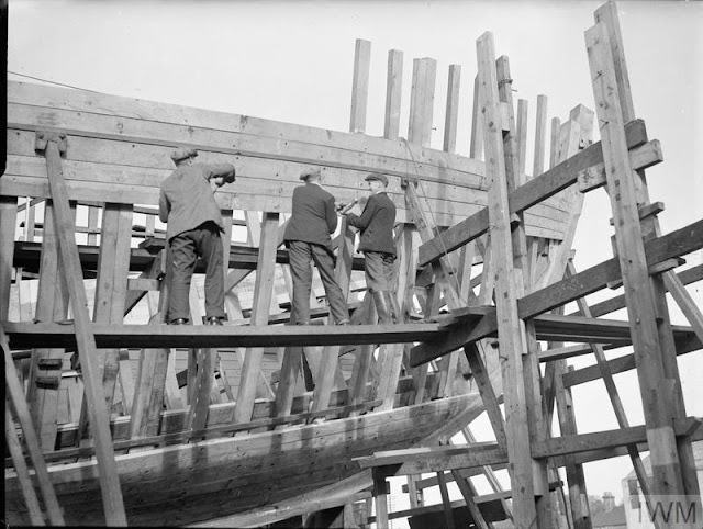
Above: A wooden minesweeper being built at a shipyard in Brightlingsea and Saxmundham. Presumably these are similar to ones built in the New Forest at places like Cracknore Hard. Photo courtesy of the Imperial War Museums: © IWM (A 13291).
Elsewhere, more decoy sites were built. This time, mainly in the form of decoy landing/airfield sites; with lights that mimicked runways. These were labelled 'Q' type decoys. Temporary mock gun sites along the coast were built, and a fake training exercise designed to appear as an amphibious assault on France were also carried out. Further deception included bombing parts of Northern France to suggest an invasion was in full swing, and creating mock camps to divert attention from real allied invasion camps. Finally, more light decoys were created to mimic ports and embarkation hards at night - designed to divert enemy attention from areas like Portsmouth. These were known as 'Quartz Light' or QL sites, and were built in empty fields; examples were to be found near East Boldre, Lymington, Sowley Pond, and at Hythe.
The New Forest also saw a Prisoner of War (POW) camp built at Setley Plain. Many prisoners worked in local businesses, and some would eventually settle in the area permanently after the war ended.
As an aside, not every bombing run by the Germans was successful, with one particularly lucky New Forest village bombed, albeit with none of the high-powered explosives detonating. This incredible story sheds some light on what could be a remarkable case of sabotage, that, if true, undoubtedly saved the lives of hundreds of people in the village of Lyndhurst.
1943-1944
It was decided by now that an allied invasion of Europe would begin by the late spring of 1944. This decision saw the build up a huge amount of troops, ships, materials, machinery and tanks - the IoW creating an ideal bit of sheltered water to assemble the fleet. The usually tranquil New Forest became a hive of activity; once-quiet country roads rumbled first with road widening and bridge strengthening schemes, and then with the sound and vibrations of vehicles - both wheeled and tracked.
Naturally, being a sea-borne invasion, the local boatyards, despite their diminutive size, were all requisitioned for the war effort.

Above: A Motor Gun Boat is launched, having just been built in Hythe, along Southampton 'Waterside', February 1943. Photo courtesy of the Imperial War Museums: © IWM (A 14601).
Even merchant and civilian boats of all sizes were to be an integral part of proceedings. Some of them were used as patrol boats; they were either given, loaned, or hired by the government. Some owners/captains stayed at the helm, and voluntarily joined the Royal Naval Auxillary Patrol (RNAP) for the duration of the war. These patrols were on the lookout for parachute mines, enemy aircraft, or raids.

Above: Boats manned by volunteers from the Royal Naval Auxillary Patrol heading along a river (location unknown). Such patrols were assembled from peacetime yachts and motor boats. Photo courtesy of the Imperial War Museums: © IWM (A 4514).
The New Forest sheltered thousands of troops, as well as the necessary equipment and supplies. The natural forest and forest tracks were a perfect way to hide all of this from enemy reconnaissance planes. Other areas were used for training, as well as for top secret weapon tests and experiments. The fact that it also had an accessible stretch of coast, and was within close proximity to Southampton was another huge bonus.
The various troops alighting from embarkation hards along the New Forest coast and in Southampton were destined to become 'Force G'; their objective being the central beach, in Normandy - codenamed 'Gold'. This was a ten-mile stretch of coast, further divided into 4 sectors (H through to K). Despite two fairly large towns along this section, it was Arromanches that would be their main objective - selected as the chosen location for Mulberry 'B'. 5 other beaches (Codenamed; Utah, and Omaha (both served by American forces), June (served by Canadian forces), and Sword (served by British forces) were served from elsewhere along the south coast of England.
Headquarters
From 1942 to 1955, Exbury House was requisitioned by the military - first as HMS Mastodon, then HMS King Alfred, and finally HMS Hawke. It's role during the time around D-Day was for administration of provisions, and arming and training crews for the various landing craft. Exbury House was also where the ill-fated raid on Dieppe was planned. It was referred to by many as the central hub of the D-Day preparations; 15 miles to the east was Eisenhower, 15 miles to the west was Patton, and 15 miles to north was Montgomery!
Other country houses and hotels were also requisitioned for military purposes; such as the Balmer Lawn Hotel in Brockenhurst, which was used by the Royal Marine Infantry. As wouldbe expected though, not every owner was willing to hand over their houses; one owner attempted to run away with the keys! Fortunately, I believe it was something like the offer of free alcohol that lured them back to hand over their property!

Above: I've spent (far too many) hours compiling and drawing this map. It shows a significant section of the New Forest, complete with as many military sites as I could find/fit on. It certainly is not an exhaustive guide, but does give some idea as to the complexity of the events in the run-up to D-Day! Note that it may not be overly accurate in places, but I have tried to cross-reference where possible with information found online.
Sites of particular interest
Whilst there were quite literally hundreds of D-Day related sites in the New Forest, I'll now look at a few select sites of particular interest; either because they are close to the area that I envisioned Bramble's Boatyard would be set, or because I feel they could offer potential as small scenes to try to reproduce - at least in part!
If you have a year to read it all (!), this fascinating document discusses a huge number of the sites; accounting for 175 pages out of the 311 page document! I have thus got plenty to fall back on when it comes to researching the impact of D-Day on the New Forest from this document alone.
Stanswood (Stansore Point, Nr. Lepe/Stone Point)
As mentioned in the last blog entry, near Lepe, 6 of the 'Phoenix' caissons were built, ready to be towed across the Channel and partially submerged to form a breakwater. These were 'B2' type Phoenix caissons, and were each some 62 metres long, 13.4 metres wide, and 10.6 metres high! For each 6000 ton caisson, a large workforce was needed to construct it. In total, it is said there were 700 men employed by Wilson Lovatt & Sons Ltd. at Stanswood, with barracks, a water tower, and other facilities built on the foreshore to accommodate them. The caissons themselves were constructed upon purpose-built brick and concrete plinths; with rails to slide them to the slipway when they were completed, for launching sideways into the sea. Two fantastic interactive, and annotated 3D models of the site can be found on this website: Wessex Archaeology - Lepe D-Day. The first shows the current remains of the site, and the latter shows a reconstruction as it would have looked in use. The site also gives additional information, for those interested.

Above: I think this Phoenix caisson is being constructed somewhere in Southampton - primarily because it was tagged in an album as Southampton, even though the title and caption do not mention a location. It does show how much more convenient docks are with their tall cranes for constructing these huge structures; as opposed to the remote foreshore at sites like Stanswood, Lepe and Stokes Bay, Gosport. Photo courtesy of the Imperial War Museums: © IWM (A 25808).
However, even prior to the Phoenix construction site (built somewhen in late 1943), a hard (labelled 'Q2') was built at Stanswood; as it was referred to in loading orders. It was primarily used to load heavy equipment (tanks, trucks, artillery, mortars, stores etc.) onto landing craft., with the road leading to it also concreted in account of the heavy traffic; as were many roads towards Lepe. The hard was also in near constant use for training troops for landings, as well as for transferring troops to the Isle of Wight and Southampton. Vessels typically used here were Landing Craft Tank (LCT), and Landing Ship Tank (LST) varieties, though I'm sure others would have been seen. All the equipment loaded onto the landing crafts were destined for the assault on 'Gold Beach' - the resulting assault force, as noted earlier, being named 'Force G'. This equipment also included the 'Sherman Crab' flail tanks (apparently being the first to arrive on 'Gold Beach' - used to clear mines), as well as vehicles from the Army Fire Service.

Above: A vehicle, travelling backwards, is loaded onto LCT 731 at an unknown hard on the south coast during exercises for the Normandy landings. This could quite easily be at Stanswood, as we know the hard was used for such exercises throughout the build-up, though there are similar photos that claim to be at Stokes Bay, Gosport. Photo courtesy of the Imperial War Museums: © IWM (A 23673).
In numbers:
- 1579 men, and 292 vehicles boarded 40 LCTs at Q2 prior to 4 weeks before D-Day
- 6407 men, and 2037 vehicles boarded 122 LCTs at Q2 in the 4 weeks before D-Day
To put that into perspective in terms of the scale of the landings, remember: that's just 1 hard out of 68 scattered along the South Coast - 13 of which were along The Solent!
Modellability?
Whilst the caisson construction site would be WAY too big to model (one of the caissons alone would measure 800mm long if scaled down!), an embarkation hard would take up little space, and would make for a nice feature if combined with a 'dolphin' or two. I could even model repairs being made to the hard so that there's a solid reason as to why no boats would be using it at the time depicted; further saving space.
[Information from both New Forest Knowledge, and D-Day Lepe Heritage Group.]
Marchwood Military Port
As I mentioned, there was a new port at Marchwood opened by 1943. It was built primarily to assist with construction of components for the Mulberry Harbours, but also to allow extra docking space for the ever-increasing flotilla of vessels waiting in Southampton Water for D-Day. It was also rail-served, with a 'long siding' connecting it to a junction just south of Marchwood Station. In terms of the Mulberry Harbour components, namely 'Whale' floating roadways, and the 'Beetle' concrete floats that supported them were constructed here. Photos show that a number of short sidings were set-up to build and/or store the 'Whales', which were accessed via a long traverser.
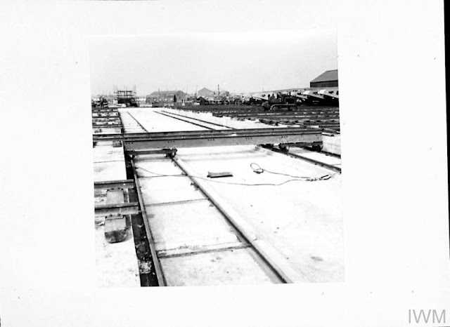
Above: The traverser at Marchwood Military Port, showing tracks on both the left and right with completed Mulberry 'Whales' on the right awaiting their time to be launched. Note the tracked tractor, which was presumably used to tow the 'Whales' onto the traverser deck visible in the centre of the photo. This would be a very interesting scene to model, but would take up a lot of space! Note also the temporary nature of the tracks, which appear to be simply laid on top of the concrete. Photo courtesy of the Imperial War Museums: © IWM (H 36898).
Modellability?
Let's face it, the traverser would be awesome to have - and I imagine it to be a working feature... but that would take up an entire board by itself, so sadly I don't think it would be realistic to model it. There is a company that have a kit for both the Whales and Beetles, but the link for the Whales no longer works. Still, there's plenty at Marchwood to consider adding, such as the construction of the Beetles; and with the kits for them still able to be bought, and some very nice reference photos to work from in the IWM collection, it's something I'm keen to do!
Clobb Copse Boatyard, nr Beaulieu
Aside from a delightful name, this is a fascinating place that is worthy of taking into serious consideration; not just in terms of modellability, but also because of its role in the D-Day preparations. In 1941, this former oyster bed was turned into a top secret building basin for various D-Day related projects. An experimental floating dry dock was built here from concrete. Once completed, it was towed in March of 1944 to Portland, where it was used during the war; presumably for repair and maintenance of small craft, although no details are given.
Meanwhile, in 1943, the boatyard was extended to create space for Mulberry 'Beetles' to be constructed. Unlike the other three sites where Beetles were built (London docks, Marchwood, and Southsea), an area was dredged, then lined with concrete to form a basin; all other sites were either in established docks (London), or directly on the shore. In this relatively small area, at least 50 of the Beetles were made, as well as 6 'Intermediate Pontoons' - which were much larger floats that connected the static 'Spud' pierheads mentioned last blog entry to the ships themselves.
Modellability?
There's a small set of fascinating photos by Lord Montagu (I believe, of Beaulieu Estate) that show all the components mentioned - including the same type of derrick crane I had planned to build anyway! Naturally, the floating dry dock would be far too big to model, but the rest lends itself perfectly to the small boatyard scene I had planned.
Eling
Yes, we're back at Eling, and I'll have to use my old sketches for this bit as I can't find any freely usable images online. Anyway, even quaint country locations like Eling were partly requisitioned by the military. At this time, Mumford's Steam Mill (now run by the company Allis-Chalmers) was still in existence. Being quite a large building in terms of the locale, and within each reach of the rail-served Eling Wharf and obviously Bartlett Water for seafaring traffic, Eling was another strategic place in which to stage certain facets of the D-Day preparations. The following information is thanks to information obtained by New Forest Knowledge - who interviewed Douglas Lancelot Stuckey - Acting Sub-Lieutenant Special Branch.
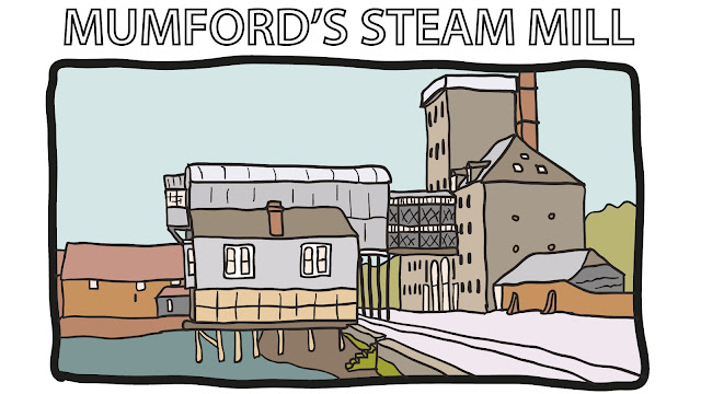
Between 1943-1944, Douglas was sent to the Allis-Chalmers mill, pictured above, which had been earmarked as a Coastal Forces Supply Depot (CFMSO). Such depots were used essentially as storage for the necessary parts and equipment needed to maintain the fleets of various vessels. In this case, predominantly Motor Torpedo Boats (MTBs) and motor launches. Everything except the main hull and ammunition were to be found in the mill; so that prompt and effective repairs could be done; this included everything from spare wiper blades to radars, to fuel tanks!
Douglas was to stay in the nearby Anchor Inn (still extant, and in use today as a pub), where he recounted various tales and experiences, often humurous; such as the time when the pub ran out of beer, or when stores would go 'missing'...
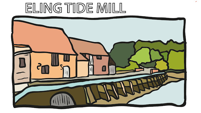
Perhaps the most remarkable story that Douglas told relates to the tide mill that I have been dying to model ever since I saw it. Being a key road link from Eling/Totton down to the various military installations along the New Forest coast, the supply depot had the unenviable task of relaying some rather... unfortunate news to the owner of the tide mill. It must be remembered that, at this time, there was a very tangible threat that the Germans would invade England. Simply put, the CFSD (supply depot) crew was to be tasked with blowing up the tide mill and causeway in the event that such an invasion should occur! Needless to say, this revelation did not go down well with the mill owner... still, the tide wasn't in use at the time, and in any case, thankfully the invasion never happened!
Modellability?
Clearly, the steam mill is out of the question in terms of modellability - it is bloody massive! However, with the potential exploding tide mill story coming to light, yet again, I really have the urge to model this delightfully quaint scene (without explosions, obviously!). That would obviously involve some compression; as, despite being a comparatively small mill, it's very long (and that's before we even look at the causeway). However, I think I've come up with a potential idea. More will be revealed next time...!
QuoteSo, that's it for this blog entry. Next time, as alluded to, I may (or may not!) have a new cunning layout plan to fit in everything that I want, and solve a few of the old problems that I've been having with my past ideas. Will it work? We'll see!
In the meantime, I hope you enjoyed this look at the New Forest at war - if you have any further information; I'd love to hear it! In any case, I hope it was at least interesting.
-
 6
6
-
 1
1
-
 1
1
-
 1
1


13 Comments
Recommended Comments
Create an account or sign in to comment
You need to be a member in order to leave a comment
Create an account
Sign up for a new account in our community. It's easy!
Register a new accountSign in
Already have an account? Sign in here.
Sign In Now